Area Recreation
This is a list of recreation sites within the township. Many other sites & activities are available in Alger and Marquette counties.
Hiking
These sites only allow exploring on foot.
Nature Hikes
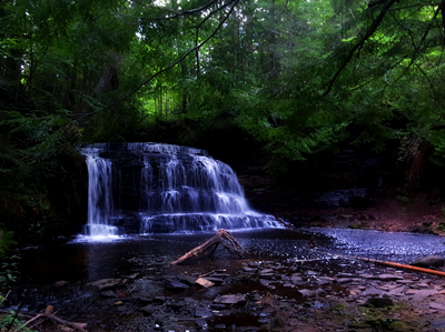
Rock River Canyon Wilderness
Two 150 foot deep river canyons, Rock River and Silver Creek, make for a challenging wilderness area  with wildly variable terrain. Elevations in the wilderness range from 680 to 1000 feet above sea level. The remote Rock River Falls runs through this area. At the edge of the canyons are sandstone outcrops that the forces of water & wind have eroded into caves (10 to 40 feet deep). During winter, ice caverns are formed by seeping water. Primary access is via Rock River Road to Federal Forest Road (FFR) 2276 (also known as Sandstrom Rd). Caution: FFR 2276 is often extremely rough and may be impassable – 4WD vehicles, chainsaw, etc strongly recommended.
North Country Trail
The North Country Trail is a national scenic trail that travels over 4,000 miles from the east coast to North Dakota. Around 20 miles of this trail run through the township – from Sandstrom Rd (also known as FFR 2276) in the east to Sand River Rd in the west. More information, GPS coordinates, and maps are available from a group of volunteers who maintain the trail, the North Country Trail Hikers .
Laughing Whitefish Lake Preserve
This 1,728 acre preserve includes three-quarters of the lake as well as over 1,000 acres of wetlands and upland forest. The George Shiras III Discovery Trail offers a one mile hike on a marked loop, which includes an observation deck overlooking the lake & river. This location is owned & maintained by the Nature Conservancy, thanks to the generous donation of land by the Reynolds family.
Tory’s Woods Conservation Preserve
Tory’s Woods is a 233 acre site donated by John & Tory Parlin to the Upper Peninsula Land Conservancy . This forest, a little east of Sand River and accessible via Section 5 road, hosts a unique array of biomes and wildlife habitat. The site currently has a looped trail system with additional signs and paths planned. Please respect the land and choose only low impact activities (hiking, bird & animal watching, snowshoeing, etc).
Memorial Nature Sanctuary
This sanctuary allows you to hike through old-growth forests with diverse plant communities and ends with a picturesque view of Lake Superior. The marked trail winds through the forest to a rocky shoreline near the mouth of the Laughing Whitefish River. Please respect the visitation policies of this site.
Historical Hikes
Tyoga Settlement (1905-1907)
Update: A four-site campground with picnic tables, fire rings, a portable toilet, etc has been opened for the upcoming camping season through cooperative efforts of the DNR, Friends of Tyoga, and Onota Township. This is the only established campground available for public use in the township.
This site has an interpretive signed trail telling the story of the mighty men who felled virgin white pines with two-man saws. Once home to a logging camp as well as a DNR campground, the looped pathway at this site meanders along the Laughing Whitefish River. To reach the trail: starting at M28, drive about 2 mi north on Laughing Whitefish Point Rd (also known as North Point Rd). Continue past the sign for Mallette Point Rd. Shortly after, there is a road to the right marked by a sign for the trail. This 1.4 mile loop is maintained through cooperative efforts of Onota Township, the DNR parks division (under Van Riper Park) and volunteers (see below).
The Friends of the Tyoga Historical Pathway
The Tyoga Historical Pathway is an ecological, historical, and educational gem that has suffered from neglect since the campground closed in 1990 (due to lack of drinkable water). Since then, it has been minimally maintained by the MI Department of Natural Resources, who have relied on assistance from area volunteers. It is vital that this unique location is preserved for all to appreciate & enjoy, for both its inherent value and the need for public recreation sites in the township. For these reasons, the Friends of Tyoga group has been formed to preserve the history of the pathway and improve the experience of those who visit the trail. Please contact John Highlen (jlhighlen at gmail.com) or John Parlin (parlinjohn at yahoo.com) if you are interested in learning more about this group.
Rock River Kilns
Charcoal was made in these kilns to provide fuel for early iron smelting. The kilns sit next to the old rail bed of the Duluth, South Shore and Atlantic Railway. The sandstone, beehive-shaped kilns were used from 1879 to 1896, when the supply of hardwoods needed for charcoal was exhausted. Details can be found on the location and history of the kilns .
Water Access
Boating
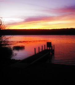
Deer Lake Boat Launch
This site offers (hard surface) ramp access to Deer Lake, a small dock for boat access, parking for nine vehicles (with trailer space), and an outhouse. Within walking distance of the Deer Lake roadside park (see ‘swimming’ below), both fishermen and recreational boaters use this site. It is run and maintained by the Department of Natural Resources (DNR) .
Lake Superior Boat Launch
Caution: there may be significant damage due to intense storms and road erosion from the high level of Lake Superior.
This site includes a ramp (hard surface) with a small dock & protective rock breakwall, parking for 18 vehicles (trailer-sized spaces) to provide boaters with access to Lake Superior. It is open to boats seasonally (non-winter months); although ice fishermen may use it for access, it is not plowed. It is maintained by the Hiawatha National Forest with cooperative efforts from Onota Township.
Laughing Whitefish River
The John H. Hammer public access site features a small ramp (gravel/dirt) for boat access near the mouth of the Laughing Whitefish River. Directions: from M28 near Deerton Rd – take Laughing Whitefish Point Rd (also known as North Point Rd) for over two (2) miles – you will cross two bridges. There will be a DNR signed road to the left. It is north of the Tyoga Trail site. Note: The connection of the river mouth into Lake Superior is often impassable to boats due to sand build-up.
This site is named for a innovative machinist who worked closely with George Shiras in pioneering night and wilderness photography near Laughing Whitefish Lake in the early 1900s (as mentioned in Superior Heartland: A Backwoods History).
Swimming
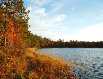
Deer Lake Park
This roadside park has a sandy beach, picnic tables, and grills. Designed with summer fun in mind, this site also offers a large parking area, outhouses, garbage cans, and is within walking distance of the Deer Lake boat ramp. This park is enjoyed by both residents and visitors for picnics, swimming, boating, and fishing.
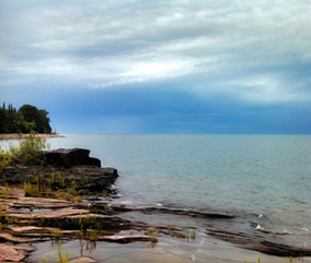
Lake Superior
Swimming access to Lake Superior can be found via scenic turnouts along M28.
Off-Road Vehicles
ATVs, Snowmobiles, + Bikes
Hiawatha National Forest
Trails & roads are available in the west half of the Hiawatha – covering a significant area on the eastern side of the township. Caution: Federal Forest roads are often rough and may be impassable.
Rails to Trails
An east-west trail covers the former railroad grade through the entire township – from Marquette County all the way to AuTrain. It is signed, graveled, and also groomed seasonally for snowmobiles. It was developed and is maintained by the DNR.